CV
>> CV (LuÌs Mateus)Publications
PhD Thesis
"Contributions to Conservation, Restoration and Rehabilitation planning design: Documentary Methodology based in terrestrial digital photogrammetry and 3D laser scanning"
>> Volume I (portuguese only!)>> Volume II (portuguese only!)
Peer reviewed publications (conference proceedings, journals)
(2019) Fern·ndez, J., Mateus, L. : Solution supporting the communication of the built heritage: Semi-automatic production path to transfer semantic LIDAR data to minecraft environment, in Digital Applications in Archaeology and Cultural Heritage, 2019, e00112,ISSN 2212-0548.
>>(2019) Mateus, L. , Fern·ndez, J., Ferreira, V., Oliveira, C., Aguiar, J., Gago, A. S., Pacheco, P., and Pern„o, J.: GRAPHICAL DATA FLOW BASED IN TLS AND PHOTOGRAMMETRY FOR CONSOLIDATION STUDIES OF HISTORICAL SITES. THE CASE STUDY OF JUROMENHA FORTRESS IN PORTUGAL, Int. Arch. Photogramm. Remote Sens. Spatial Inf. Sci., XLII-2/W15, 767ñ773, 2019.
>>(2019) Mateus, L., Fern·ndez, J., Ferreira, V., Oliveira, C., Aguiar, J., Gago, A. S., Pacheco, P., and Pern„o, J.: TERRESTRIAL LASER SCANNING AND DIGITAL PHOTOGRAMMETRY FOR HERITAGE CONSERVATION: CASE STUDY OF THE HISTORICAL WALLS OF LAGOS, PORTUGAL, Int. Arch. Photogramm. Remote Sens. Spatial Inf. Sci., XLII-2/W11, 843-847, 2019.
>>(2016) D. Verniz, L. Mateus, J. P. Duarte, V. Ferreira, ; "3D Reconstruction Survey of Complex Informal Settlements. Towards an understanding of the genesis of form", in proceedings of eCAADe 2016 Conference, vol. 2. 22-26 August, Oulu School of Architecture: Finland. pp. 365-370
>>(2016) M. Barbosa, P. Pauwels, V. Ferreira, L. Mateus; "Towards increased BIM usage for existing building interventions", Structural Survey, Vol. 34 Issue: 2, pp.168-190, doi: 10.1108/SS-01-2015-0002
>> (Award for Excellence - 2017)(2015) J. Covas, V. Ferreira, L. Mateus; "3D Reconstruction with Fisheye Images. Strategies to Survey Complex Heritage Buildings", in Proceedings of the 2nd International Congress on Digital Heritage 2015, Granada, Spain, IEEE Catalog Number: CFP1508W-USB, 28sep-2oct 2015. ISBN: 978-1-5090-0047-0.
>>(2015) M. Bazargani, L. Mateus, M.A. Loja; "Planar Surfaces Recognition in 3D Point Cloud Using a Real-Coded Multistage Genetic Algorithm", in EvoApplications, 18th European Conference on the Applications of Evolutionary Computation, Copenhagen, Denmark, Springer International Publishing, 8-10 April 2015. ISBN (online): 978-3-319-16549-3. pp 529-540
>>(2014) V. Ferreira, L. Mateus, J. Aguiar; "Site Recording Using Automatic Image Based Three Dimensional Reconstruction Techniques", in Archaology in the digital Era: papers from the 40th Annual Conference of Computer Applications and Quantitative Methods in Archaeology (CAA) (editor Philip Verhagen), Amsterdam University Press. ISBN: 9789089646637. pp. 308-315
>>(2014) M. Bazargani, L. Mateus, M.A. Loja; "Logarithmically Proportional Objective Function for Planar Surfaces Recognition in 3D Point Cloud", in proceedings of Sixth World Congress on Nature and Biologically Inspired Computing (NaBIC), Porto, Portugal, July 30, 31 - August 1. Editors A. M. Madureira et al. ISBN: 978-1-4799-5937-2. IEEE catalog number: CFP1495H-ART. pp. 275-280
>> >>(2013) D.A. Carvalho, L.M. Mateus, V.M. Ferreira; "Three-dimensional reconstitution of an ex-place: The submerged Vilarinho da Furna, Portugal", in proceedings of CIAV 2013 | 7th ATP | VERSUS, Vila Nova de Cerveira, Portugal, 16-20 October. Editors Mariana Correia et al. CRC Press, Taylor and Francis group. ISBN: 978-1-138-00083-4. pp. 827-832
>>(2013) L. Mateus, F. Roseta, F. Monteiro; "Architecture and parametric design: A prototype for a kiosk", in proceedings of the 6th International Conference on Advanced Research in Virtual and Rapid Prototyping, Leiria, Portugal, 1-5 October. Editors Paulo Jorge S. B·rtolo et al. CRC Press, Taylor and Francis group. ISBN: 978-1-138-00137-4. pp. 493-496
>>(2013) L. Mateus, V. Ferreira; "3D Digitization in Architecture Curriculum", in proceedings of eCAADe 2013 Conference on Computation and Performance. 18-20 September, Delft University of Technology: Delft, Netherlands. ISBN: 978-94-91207-05-1. pp. 445-452
>>(2013) F. Coutinho, L. Mateus, J. P. Duarte, V. Ferreira, M. Kruger; "From Poin Cloud to Shape Grammar to Grammatical Transformations", in proceedings of eCAADe 2013 Conference on Computation and Performance. 18-20 September, Delft University of Technology: Delft, Netherlands. ISBN: 978-94-91207-05-1. pp. 655-663
>>(2013) L. Mateus, M. Barbosa, V. Mota Ferreira; "An expeditious methodology to correct the closure error of point clouds registration", in proceedings of the 1stInternational Conference on Algebraic and Symbolic Computation (SymComp2013). 9-10 September, IST: Lisbon, Portugal. ISBN: 978-989-96264-5-4. pp. 422-431
>>(2013) L. Mateus, F. Roseta, F.V. Monteiro; "Visual programming as tool for architectural Design", in proceedings of the 1stInternational Conference on Algebraic and Symbolic Computation (SymComp2013). 9-10 September, IST: Lisbon, Portugal. ISBN: 978-989-96264-5-4. pp. 412-421
>>(2013) M. Amaral, J.A. Rodrigues,,M.A.R. Loja ,V. Mota Ferreira and L. Mateus; "Characterization and modeling of building cracks using 3d laser scanning as rehabilitation support", in proceedings of the 1stInternational Conference on Algebraic and Symbolic Computation (SymComp2013). 9-10 September, IST: Lisbon, Portugal. ISBN: 978-989-96264-5-4. pp. 386-399
>>(2012) MATEUS LuÌs, FERREIRA Victor, AGUIAR JosÈ; ìCase Studies in ìConvento de Cristoî: recording and documentationî, in DisegnareCON, Vol. 5, Numero Speciale(2012) - DOCO 2012 (editors R. Mingucci, C. Bartolomei, L. Bravo, S. Garagnani). ISSN: 1828 5961. pp. 169-172
>>(2012) MATEUS LuÌs, FERREIRA Victor, AGUIAR JosÈ, DIAS Ana; ìTerrestrial Laser Scanning and Automatic Digital Photogrammetry as tools for the Archaeological Recording ñ The case Study of Convento de Cristoî, in proceedings of the International Conference on Best Practices in World Hertitage. Menorca, Spain. ISBN: 978-84-695-6782-1.pp. 400-412
>>(2012) MATEUS LuÌs, BRITO Nelson, FERREIRA Victor, BARBOSA Margarida, AGUIAR JosÈ; ìNew tools for visual assessment of building deformationsî, proceedings of the International Conference on Structural Analysis of Historical Constructions, SAHC 2012, 15-17 October 2012, Wrocklaw, Poland. Vol. 3. pp. 2463-2470. ISBN: 978-83-7125-219-8.
>>(2012) MATEUS LuÌs, FERREIRA Victor, AGUIAR JosÈ, BARBOSA Margarida; ìTLS and digital photogrammetry as tools for conservation assessmentî, proceedings of 3rd International Conference on Heritage and Sustainable Development - Heritage 2012. eBook ISBN: 978-989-95671-8-4. Editors RogÈrio AmoÍda, SÈrgio Lira, Cristina Pinheiro. Published by Green Lines Institute.
>>(2012) BRITO Nelson, MATEUS LuÌs, SILVA Manuel Gameiro; ìNew opportunities for buildings in city centersî, proceedings of 4∫ Congreso de patologÌa y rehabilitaciÛn de edificios. PATORREB 2012
>>(2011) AGUIAR JosÈ, MATEUS LuÌs, FERREIRA Victor; "O Projecto de conservaÁ„o e as novas metodologias de documentaÁ„o. EvoluÁıes recentes e alguns casos de estudo (Projecto FCT:PTDC/AUR/66476/2006)", proceedings of the International Symposium "PatrimÛnio em construÁ„o - contextos para a sua preservaÁ„o", pp. 335-342, LNEC, 25-26 Novembro de 2011
>>(2008) MATEUS LuÌs, FONTES LuÌs, AGUIAR JosÈ, CATAL√O Sofia, BOTICA Nat·lia, AGOSTINHO Francisco; ìA report on multiple approaches to the S. Frutuoso of MontÈlios Chapel surveyî, proceedings of the 9th International Symposium on Virtual Reality, Archaeology and Cultural Heritage ñ VAST 2008, p.51-55, Departamento de Inform·tica da Universidade do Minho, Braga, 2008, ISBN 978-972-99166-7-0
>>(2008) MATEUS LuÌs; ìEvaluating a low cost photogrammetry method with 3D laser scanningî, proceedings of the 3rd International Conference of Geodesy, Cartography, Navigation and Geoinformatics ñ GEOS 2008 (CD), p.317-326, VUGTK - Milan Talich (ed), Praga, 2008, ISBN 978-80-85881-29-5
>>(2007) MATEUS LuÌs; ìRectificaÁ„o de desenho vectorial (Rectification of vectorial drawingî, Novas perspectivas em Sistemas e Tecnologias de InformaÁ„o ñ CISTI 2007 (poster - CD), Universidade Fernando Pessoa Editions, Oporto, 2007, ISBN 978-972-8830-88-5
>>Other publications
(2011) MATEUS LuÌs, FERREIRA Victor, AGUIAR JosÈ; ìUsing laser scanning data to perform iconic and geometric analysis of a built structure: the dome of the Arco of Rua Augusta in Lisbon", poster in the "ISPRS Working Group V/2 Conference - Cultural heritage data acquisition and processingî, 17th - 19th August, The King's Manor - York - UK, 2011. (poster presentation - Best poster award - 3rd prize)
>>(2010) MATEUS LuÌs, MARTÕN Juan JosÈ, R⁄BIO JosÈ MartÌnez, ALONSO Jes˙s; "Laser Scanning 3D: Nuvens de pontos como DocumentaÁ„o Prim·ria do PatrimÛnio - O caso do Castelo de Mota del MarquÈs em Valladolid (Laser Scanning 3D: Point Clouds as basic Heritage documentation - Mota Castle in Valladolid)", in Linha do Horizonte, N∫ 1, Lisbon, 2010, pp. 124-133, ISBN 978-972-9346-13-2
>>(2007) MATEUS LuÌs; "MÈtodo de fotogrametria elementar implementado com rotinas em Autolisp (Elementary photogrammetric method implemented with Autolisp routines)", in Cadproject N∫ 31, Lisbon, 2007, pp. 48-50
>>(2007) MATEUS LuÌs; "MÈtodo pr·tico para levantamento de fachadas de Arquitectura (Practical method to survey architectural faÁades)", in Artitextos N∫ 4, Editorial Center of the Faculty of Architecture - Technical University of Lisbon, Lisbon, 2007, pp. 143-150 , ISBN 972-97354-4-1
>>(2006) MATEUS LuÌs; " Geometria numa escola de Arquitectos (Geometry at an Architecture School) ", in Artitextos N∫ 1, Editorial Center of the Faculty of Architecture - Technical University of Lisbon, Lisbon, 2006, pp. 31-43 , ISBN 972-97354-4-1
>>(2002) MATEUS LuÌs; ìAxonometrias ñ DeterminaÁ„o dos coeficientes de reduÁ„o por via analÌtica (Axonometry - Analytic calculation of the reduction coefficients)î, in Boletim n∫ 19, APROGED, Oporto, 2002,pp. 15-20 , Dep. Leg.: 186158/02
>>(2001) MATEUS LuÌs; ìA Elipse ñ Como determinar o eixo maior e menor de uma elipse definida por dois di‚metros conjugados? (The ellipse ñ How to determine the axis of an ellipse given to conjugate diameters?)î, in Idade da Imagem N∫ 1, IADE, Lisbon, 2001, pp. 46-48
>>(2001) MATEUS LuÌs; ìGeometria e pensamento geomÈtrico na utilizaÁ„o de meios inform·ticos em Arquitectura (Geometry and geometrical thinking when using informatics in architecture)î, in Boletim n∫ 16, APROGED, Oporto, 2001, pp. 7-12
>>Other academic publications (only publicated here on-line)
(2004) MATEUS LuÌs; "Sistema AxonomÈtrico de representaÁ„o: HistÛria, Teoria e Pr·tica (Axonometric system of representation: History, Theory and Practice)", (Provas de Aptid„o PedagÛgica e Capacidade CientÌfica - Trabalho de SÌntese), FAUTL, Lisbon, 2004, 179 p.
>>(2004) MATEUS LuÌs; "InvenÁ„o e representaÁ„o de uma superfÌcie regrada definida por trÍs directrizes (Inventing and representing a ruled surface defined by three directresses)", (Provas de Aptid„o PedagÛgica e Capacidade CientÌfica - relatÛrio para uma aula pr·tica), FAUTL, Lisboa, 2004, 71 p.
>>Organization
2011
MATEUS LuÌs, AGUIAR JosÈ: organization of the ì3nd International Seminar ArcHC_3D ñ Restoration and Rehabilitation: Surveying Methodologiesî integrated in the research project ìArchitectural Heritage Conservation: a Methodology to 3D Laser Scanning and Digital Photogrammetry Documentationî (PTDC/AUR/66476/2006). Supported by Culture Ministery - IGESPAR, ICOMOS-Portugal, FAUTL-CIAUD. Financed by FCT. FAUTL, 31st January.
>>2009
MATEUS LuÌs, AGUIAR JosÈ: organization of the ì2nd International Seminar ArcHC_3D ñ Restoration and Rehabilitation: Survey Methodologiesî integrated in the research project ìArchitectural Heritage Conservation: a Methodology to 3D Laser Scanning and Digital Photogrammetry Documentationî (PTDC/AUR/66476/2006). Supported by Culture Ministery - IGESPAR, ICOMOS-Portugal, FAUTL-CIAUD. Financed by FCT. FAUTL, 29th May.
>>2007
MATEUS LuÌs, AGUIAR JosÈ: organization of the ìSeminar ArcHC_3D ñ Conservation, Restoration and Rehabilitation: Survey Methodologiesî integrated in the research project ìArchitectural Heritage Conservation: a Methodology to 3D Laser Scanning and Digital Photogrammetry Documentationî (PTDC/AUR/66476/2006). Supported by Culture Ministery - IGESPAR, ICOMOS-Portugal, FAUTL-CIAUD. Financed by FCT. FAUTL, 11th May.
>>AutoLISP
One of my personal interests is the development of Autolisp routines to solve representation problems. Here you can find and download my lisp routines. If you wish you can improve them. I'm sorry but the comments inside the code are in portuguese. I would appreciate your comments and suggestions to improve the routines as well as ideas for new ones! The latest routines will be placed on top. To make it easier I only put here one *.zip file with all routines that I will update.
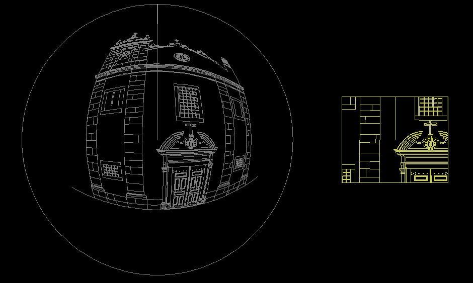
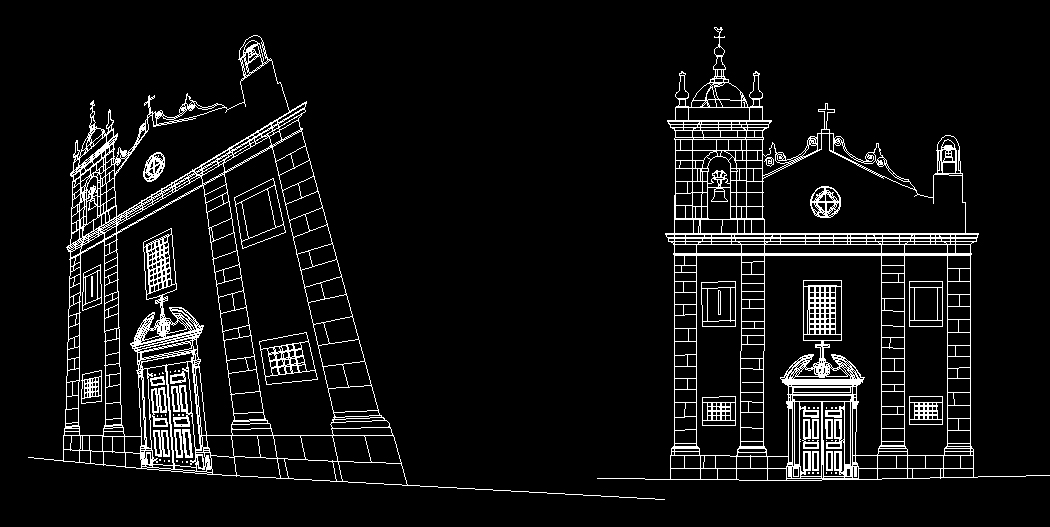
>> download allTo simulate a spherical photograph (It is an approximate perspective!) from a 3D line model (foto_esferica.LSP)
This is divided in 3 parts. First type cam_esf to define the camera. It asks you for the principal distance (in mm), and for a scale factor. If one drawing unit is 1m I suggest a scale factor of 0.1. Then type objecto to select the object to be imaged. Note that the routine only work with lines. After type foto_esf to get the picture. It asks you for the station point and for the target point. You can take as much pictures as you want. If you want to add an object to a taken photo you type objecto to select the object and snapshot to add it to the picture. It doesnít crop the image outside the boundaries of the ìsensorî nor does filter the elements behind the camera. That is a limitation. For successive pictures of the same object with the same camera definition only use foto_esf. Note that you have to create two layers: foto_e and foto_o. It returns two images, one spatialy oriented and another at the origin. Find an example image bellow comparing a standard perspective with the spherical perspective.
To draw an ellipse given to conjugate diameters (elipse_lista.LSP)
It works fine in WCS. Type eli and define the center and the endpoints of the conjugate diameters.
To define a projective transformation (rectificador.LSP)
This is a routine similar to homograf but it based on a different algorithm. It gives you the possibility to choose lines instead of points as control data. In fact, given the lines it calculates intersection points. So it requires that following lines intersect. To make it work you can type 4p4p1 or 4l4l1 (in these cases you are choosing points or lines, respectively, as control data; you are also picking the four control points or lines first in the distorted drawing), or you can type 1p1p4 or 1l1l4 (in these cases you pick one control point or line in the distorted drawing followed by its homologous control point and you repeat this 4 times). Once the projective transformation is defined you can type transf to transform additional data. Note that you can only apply this to lines. It works fine in WCS.
To determine the best fit point to converging lines (1_pt_fuga.LSP)
This routine was intended to be used when drawing over perspective images. If you type spf and then select a set of converging lines it returns the best fit point (I obviously call it the vanishing point). If you type spf_r it also redraws the lines converging to the determined point. After the point is determined type sp_lv to draw additional lines from the vanishing point. If you take a look to de code you find extra information that is not used. Use it if you need it!
To sum the lengths of a set of lines (ct_jts.LSP)
Type ctjts. It returns the number of lines, the total length, and the average length.
To sum the lengths of a set of lines, open polylines, arcs of circles, arcs of ellipses and splines (ct_jts_geral.LSP)
Type ctct. It returns a list with partial lengths (ignore the last value that is 0), the total length and the average length. It doesnít work with regions, circles, ellipses and closed polylines. With regions it doesnít work at all. With the others it returns 0 length. Sorry!!! Feel free to improve it!!!
To sum the areas of a set of polylines, arcs, circles, ellipses and splines (ct_areas.LSP)
Type ctar. It returns a list with partial areas (ignore the last value that is 0), the total area and the average area. It doesnít work with regions.
To simulate a photograph (It is a perspective!) from a 3D line model (foto.LSP)
This is divided in 3 parts. First type camara to define the camera. It asks you for the principal distance (in mm), for the sensor width (in mm), for the sensor height (in mm), and for a scale factor. If one drawing unit is 1m I suggest a scale factor of 0.1. Then type objecto to select the object to be imaged. Note that the routine only work with lines. After type foto to get the picture. It asks you for the station point, for the target point, and for a rotation angle around camera axis. You can take as much pictures as you want. If you want to add an object to a taken photo you type objecto to select the object and snapshot to add it to the picture. It doesnít crop the image outside the boundaries of the ìsensorî nor does filter the elements behind the camera. That is a limitation but nevertheless it can be used to plan a photogrammetric survey. For successive pictures of the same object with the same camera definition only use foto.
To determine the angle between to vertical adjacent faÁade plans (planta.LSP)
It is supposed that you draw over a photo taken with a camera with horizontal position. It recommended that you correct the image for distortions. This can be usually done with the camera software. Then insert the image into AutoCAD and draw the intersecting line of the two faÁades (let us call it Li). Then draw a vertical line over the left faÁade (let us call it Le) and a vertical line over the right faÁade (let us call it Ld). These 3 lines should correspond to lines of equal length in the real object. Then you have to know the real length (on the real object) of line Li (let us call it LVi), the real distance between Le and Li (let us call it LEI), and the real distance between Li and Ld (let us call it LID). You can draw a vertical line and two horizontal lines corresponding to these lengths. Then type planta. Now you have to select Li, Le, Ld, LVI, LEI, LID, and pick a point to be the vertex of the angle. Hope you understood! Enjoy!
To develop a cylindrical surface (planif_cil.LSP)
Suppose you have a vertical cylinder corresponding to a circular wall. For example, you draw the bricks or the stones of the wall approximately on the cylinder (only lines). Now you want to develop the cylinder to a plan in order two make a drawing with the real dimensions of the circular wall. Draw a circle (let us call it CC) corresponding to the horizontal projection of the cylinder. It is also recommended that you draw two opposed vertical lines (let us call them V1 and V2) on the cylinder. Now type planif, then pick the circle CC, select the ìbricksî or ìstonesî and the lines V1 and V2, and finally select the insertion point of the developed surface drawing.
Webmaster:LuÌs Mateus | © 2010 | Updated: 06/09/2019