SRDA Syllabus
Curricular Unit Syllabus. The learning objectives are to understand and master the technical and graphical representation of architecture design documentation, with production of outputs in various media (screen and print).
Assistant Professor, Lisbon School of Architecture
Dep. of Drawing, Geometry and Computation
This as been a very busy month, with the end of the first semester, delivering work done for improving acessibility to our World Heritage sites, and working on a 3d survey of Castelo de Vila Viçosa.
Curricular Unit Syllabus. The learning objectives are to understand and master the technical and graphical representation of architecture design documentation, with production of outputs in various media (screen and print).
SRDA Introduction [pdf]. Professor and Unit presentation.
Introduction to Graphic Software and Hardware [pdf]. Image Editing (pixel and vector); CAD 2e & 3D; Render; BIM. Digital Pen and tablets. Rapid Prototyping: 3D printing, CNC router and laser cutters.
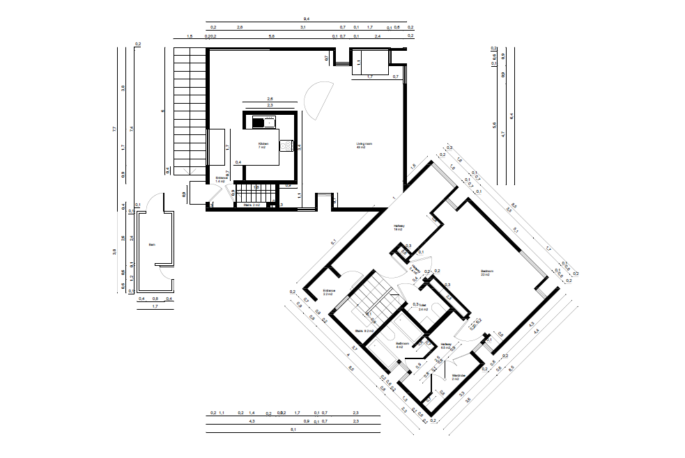
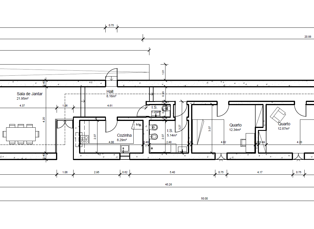
Introduction to Technical Drawing [pdf]. Evolution of technical drawing from 15th Century hand drawing to XXIst Century. Technical drawing graphic rules and examples.
SRDA Introduction [pdf]. Professor and Unit presentation.
Introduction to Software and Hardware [pdf]. Professor and Unit presentation.
Curricular Unit Syllabus. Introduction to drawing for design documentation and representation, both technical (cad) and graphical (raster/vector), producing outputs for various media (web and print).
SRDD Introduction [pdf]. Professor and Unit presentation.
Introduction to Graphic Software and Hardware [pdf]. Image Editing (pixel and vector); CAD 2e & 3D; Render; BIM. Digital Pen and tablets. Rapid Prototyping: 3D printing, CNC router and laser cutters.
Introduction to Technical Drawing [pdf]. Evolution of technical drawing from 15th Century hand drawing to XXIst Century. Technical drawing graphic rules and examples.
Support documents.
Curricular Unit Syllabus. This unit introduces students to 3D modeling, ilumination, texturing, rendering and 3D animated visualization.
SRDD Introduction [pdf]. Professor and Unit presentation.
Introduction to Graphic Software and Hardware [pdf]. Image Editing (pixel and vector); CAD 2e & 3D; Render; BIM. Digital Pen and tablets. Rapid Prototyping: 3D printing, CNC router and laser cutters.
Introduction to Technical Drawing [pdf]. Evolution of technical drawing from 15th Century hand drawing to XXIst Century. Technical drawing graphic rules and examples.
Support documents.
Introductory unit, teaching the basics of laser scanning, photogrammetry, point cloud editing.
3rd Cycle Elective Unit, teaching laser scanning, photogrammetry, point cloud editing, 3d mesh model export and editing.
Introductory unit, introducing the most recent tools and techniques to represent existing architecture, trough a Scan-to-BIM process.
3rd Cycle Elective Unit, introducing the most recent tools and techniques to represent existing architecture, trough a Scan-to-BIM process, applying it to building documentation and project management.
The transformation of 3D survey data into as-built parametric smart models is currently a challenge, this article addresses the creation of an HBIM model of heritage assets using 3D laser scanning and photogrammetry, by presenting a case study: The Engine House Paços Reais.
Discussion of how three-dimensional documentation played a fundamental role on the several stages of the process of safeguard and restoration of the house and farm of Valflores (16th century Renaissance civil architecture), namely after 2007, permitting to gain insights about metrics, space and form distributions, deformations, structural condition, state of conservation, history, and allowing dissemination and public engagement.
This paper discusses the graphical data flow, based on terrestrial laser scanning (TLS) and photogrammetry, for the conservation and rehabilitation project of the Fortress of Juromenha, located nearby the Portuguese-Spanish border in the Alentejo Province. We describe the strategy of data acquisition (including GPS positioning, drone imagery, ground based imagery, and TLS survey), the processing, the outputs and discuss how the data was shared with the project team and how it influenced the design.
In this study we use the case study of the conservation project of the historic walls of Lagos to look on ways to improve the dialog between agents in the conservation planning process, using digital graphical documentation (based on photogrammetry and terrestrial laser scanning).
In this paper, the authors investigate the general content and usage of existing BIM standards for new constructions, describing specifications about BIM deliverable documents, modeling, and collaboration procedures. The authors suggest to what extent the content in the BIM standards can also be used for interventions in existing buildings. These suggestions rely heavily on literature study, supported by on-site use case experiences.
In this paper we present a research of use of fisheye lenses in photogrammetry, for capturing medieval castles' geometric and radiometric information of hard to reach places.
In this paper we present a research of use of fisheye lenses in photogrammetry, for capturing medieval castles' geometric and radiometric information of hard to reach places.
The objectives of this paper are to demonstrate that image based three dimensional reconstruction techniques, such as structure from motion (SFM) and multi-view-stereo (MVS) enable the production of documentation with comparable quality to the one produced with terrestrial laser scanning (TLS). We start by demonstrating that proposition and then, will present two more case studies where those techniques were used to produce data for the archaeological recording.
In this paper we describe an experience undertaken in the Faculty of Architecture of Technical University of Lisbon, concerning the introduction of a 3D Digitization course in the frame of the PhD doctorate program in Architecture and in the frame of the Master's programs in Architecture, Urbanism and Design.
#digital heritage #heritage #laser scanning #photogrammetry #3d modeling #architecture documentation #virtual reality #visualization #fabrication #architecture #architecture pedagogy.
The scope of SizaATLAS project is to address a comprehensive inventory of all of Siza’s built works, and to develop a detailed documentation and analysis of the 18 buildings selected for the World Heritage List.This research and the comparison with other contemporary architecture will result in a better understanding of the unique value of Siza’s architecture, in a national and international context.
This research project aims to develop a comprehensive tool for deep building renovation, which comprises the building survey, design generation, building geometry optimization, and Energy Systems (ES) and Construction System (CS) optimization in single BIM add-on tool.
The use of digital tools for the documentation of tangible or intangible heritage is not just a technical issue. There needs to be an appropriate framework at the level of principles and guidelines that should guide every documentary action, as well as the need for the availability and access to a repertoire of good practices. The purpose of EduDigHe project is to produce a theoretical and practical reflection on the impact that digital tools can have in terms of asset knowledge production and the possibilities that open with the combination of different approaches and methods.
This research project aims to develop a comprehensive tool for deep building renovation, which comprises the building survey, design generation, building geometry optimization, and Energy Systems (ES) and Construction System (CS) optimization in single BIM add-on tool.
This research intended to empirically test the hypothesis of «gesture»: the existence of a global coherence of the visual and walking trajectory made as we explore a building. The programmed experiment of the research project took place in the Alcobaça Monastery.
Research project that studied workflows to extract information (automatic extraction of geometries with different levels of detail, analysis and image processing) from 3D data acquired with 3D laser scanning and digital photogrammetry, and to test its direct applicability in the context of action planning intervention on the built environment.
Research project that was the starting point for the Archc3D research group foundation, and allowed us to focus on a common goal of Digital documentation of Heritage, to support Conservation and Rehabilitation.
Modelação 3D dos monumentos a partir de levantamentos existentes: Palácio Nacional de Mafra, Convento de Cristo, Mosteiro da Batalha, Mosteiro de Alcobaça, e Museu Nacional Machado de Castro. Levantamento fotogramétrico de várias esculturas ou elementos decorativos dos monumentos e produção/edição de respetivos modelos 3D. Produção de modelos por impressão 3D FDM. Modelos ficarão em exposição nas entradas dos respetivos monumentos, para apoio a utentes com deficiência visual.
Surveying of "Forte de Paimogo" in Lourinhã, including the underground cistern. It was done a mixed survey using terrestrial laser scanning (TLS), photogrammetry with drone imagery and ground based imagery, and GPS positioning. This included the production of 3D point clouds, 3D textured models from exterior, interior and cistern, ortho-imagery, videos and CAD drawings. The activity was framed by a cooperation protocol, for academic research, between FAULisboa and the municipality of Lourinhã. Participants: Luís Mateus, Victor Ferreira, Marta Orszt, Graziella Del Duca, Miguel Rafael.
Surveying and modelling of "Pavilhão de Exposições" of ISA.ULisboa. This project consisted in the development of a scan-to-BIM methodology to document the building and to prepare the graphical documentation for the resotration project. This activity was framed by a cooperation protocol for research established between FA.ULisboa and ISA.ULisboa. Participants: Luís Mateus, Victor Ferreira, Jorge Fernández, Gustavo Rocha.
Surveying of the Museum of Natural History and Avelar Brotero house in the Botanic Garden of Ajuda. It was done a mixed survey using terrestrial laser scanning (TLS) and photogrammetry. Here you can do a walkthrough based on TLS panoramas. This was a cooperation protocol, for academic research, between FAULisboa and ISA-ULisboa.
Surveying of the Fortress of Juromenha. Here we used terrestrial laser scanningand photogrammetry This was a cooperation with Pedro Pacheco Arquitetos and it was integrated in the restoration projec of the fortress. The final client was the municipality of Alandroal in Alentejo.
Laser scanning survey of the exterior of National Palace of Mafra. This research involved DGPC - (General Directorate of Cultural Heritage)
3D laser scanning survey of the "Infantes" (young princes) wing of the National Palace of Mafra. Support to the 4th year "Laboratório" Curricular Unit of MIntReab. The wing had been recently released to be used by the Palace, and the chalenge was to propose ways of including the wing in the general visit to the Palace. Prof.João Pernão.
Surveying of Pegões Aqueduct in Tomar. This work was contracted by the Municipality of Tomar. The survey was done using Terrestrial Laser Scanning, Photogrammetry and GPS positioning. It was also used a drone for aereal imagery. The goal was to do CAD drawings to be used for the structural rehabilitation works.
Surveying of the exterior of Palácio de Belém in Lisbon (gardens and building exteriors). This work was contracted by the office of the President od the Portuguese Republic. The survey was done using Terrestrial Laser Scanning and aereal imagery collected with a Helium ballon. The goal was to do generate data for the management of the property.
Surveying of Arco da Rua Augusta in Lisbon (Praça do Comércio). The survey was done using Terrestrial Laser Scanning, topography for general control and Direct measurements. The goal was to produce CAD drawings to be used for the rehabilitation planning by Arch. Alves Costa's office.